Pages

Sunday, December 24, 2006

Canal Walk: Sollom to Tarleton to Rufford

I parked at Sollom Lock, there is space for about 7 cars and was lucky to find a space. This lock used to be the link between the canal and the River Douglas before it was moved to Tarleton and the section of river inbetween was added to the canal. Now the lock is there in name alone, the road that crosses Strand Bridge is Lock Lane.

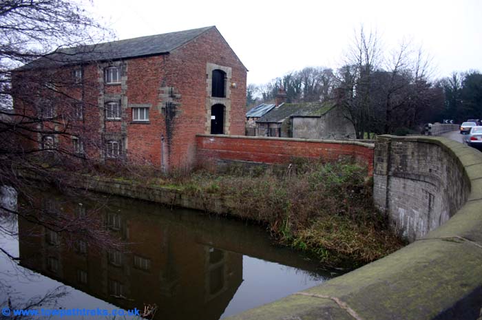
The stone chamber is still there but the gates and paddles have gone. You can see where the gates were fitted, the stonework and metal hinges show where the gates were attatched. The towpath from the Junction at Burscough finishes here and beyond the lock there is nothing more than a grassy track to follow. It is more of a river ramble than a towpath trek as you follow the former River Douglas along behind the tall reeds. This stretch of water has had many names: Lower Douglas Navigation, Leeds Liverpool Canal Rufford Branch, River Douglas, River Alsand. Its about a mile from the old river lock to Bnk Bridge #11. This bridge carries the A565 over both the canal and the tidal river Douglas. Its a very busy road with cars zooming across the quiet canal. Motorists will notice the warehouse next to the bridge inbetween the river and the canal.

From here its another mile to the river lock at Tarleton,but the track deteriorates further and I didnt fancy walking through the undergrowth to follow it.
There was no sign of the milepost which should be near the bridge marking 6 miles to the junction with the mainline. After a bottle of sparkling glucose drink I turned around and headed back to Sollom and then on to look for the milpost four miles from the junction.
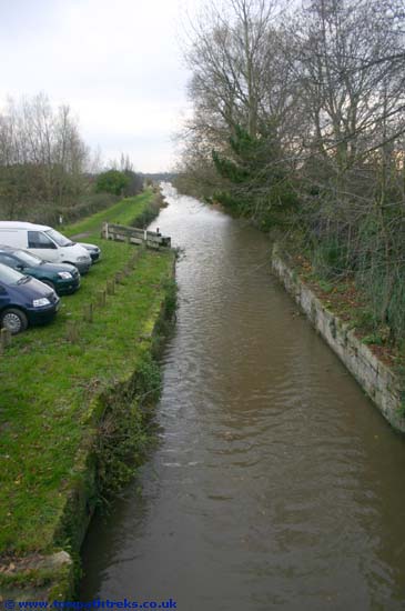
The towpath between Sollom and Rufford is in places at the same level as the water in the canal. I was glad of my wellies as I negotiated the planks over the puddles and streams flowing from the canal across the towpath.
There was again no sign of the the four mile milepost so after taking some photos from Spark bridge I turned around and went back to the car.

Monday, December 11, 2006

Canal Walk: Halsall

It was a cold, rainy and windy day, no day for towpath trekking but try telling that to a bored black Labrador. After much excitement we arrived at the canal and parked at the moorings of the Pride of Sefton. With wellies on and the hound straining at the leash we set off Wigan-wards. The towpath alongside the moored boats is very muddy even when it isn’t raining and there is always the smell of a septic tank wafting about. The Ship Inn is on the left as you approach the bridge which shares its name, Ship bridge #22. In the summer the willow and the shoals of small fish make this a very pleasant spot; in December in the rain it is a bit bleak. There is a half mile post here, marking 17.5 miles from Liverpool. The moored boats are on the bankside on the Wigan side of the bridge. Few have people living onboard them. There is half a mile of exposed towpath before we reached Harkers Bridge #23 and Halsall cutting beyond. In the reeds on the bankside was a cruiser that had slipped its mooring and been blown along the cut. The milepost showing 18 miles to Liverpool is near the spot where the Leeds Liverpool canal was started. The first sod was cut here over 300 years ago. This is one of my favourite spots on the canal.
Just past the next bridge, Halsall Hill bridge #24 is a winding hole, a wide bit of canal for boats to turn around in. The bank here has collapsed allowing young dogs to get down to the water and find out that canals are a bit too deep to paddle in. Not only was it still raining but now we had a wet dog shaking herself next to us.
At the next bridge Halsall Warehouse bridge #25 is the Saracens Head. The pub looked warm, dry and inviting as we passed it in the rain. By the bridge is the Halsall Navvy, on his own in the rain today.
We pressed on past milepost 19, past bridge 26 Hulme’s bridge where dog and trekker demonstrated how the grooves on bridges were worn by ropes. The horse’s tow ropes must have been the same thickness as a dogs lead. There was again no sign of the 19.5 mile half milepost, it is hidden in the brambles. How it managed to get onto the 2005 OS map I don’t know.
At Weavers bridge #27 we turned around to walk back this time with the wind and rain on our faces.