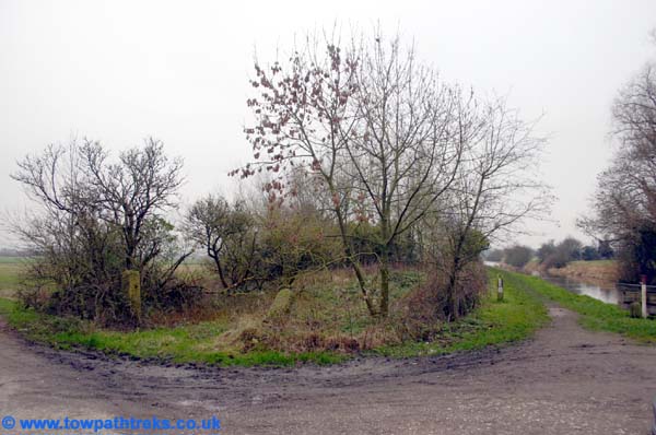
Blue skies over Lancashire today but only a small trek planned. We parked at Appley Bridge #42 in the public car park and set off towards the locks. This is a favourite stretch of canal for me. There are three locks at Appley locks. Boaters had a choice of using one deep lock or two shallower ones. The single lock was put in to save water, something which was a big concern on the Leeds Liverpool during its working life. Today I wanted to visit the two shallower locks which are disused these days.
Pennine Waterway by Gordon Biddle has a photo of the last horse drawn barge leaving Appley Lock in 1960. Anyone who has visited the locks will notice the biggest change since that time; the photograph shows a large house in between the two sets of locks and some houses to the left of the canal. There is no sign at all of these buildings today. Indeed it is hard to image there was enough room for a house on the thin strip of land between the locks and the field to the left looks like any other. There are many sites along the canal where canalside buildings have disappeared without trace, only now visible on old maps and photographs.
The two locks are in a poor state today. The balance beams have rotted and the gates nailed shut. The bridge over to the far side has gone from the upper lock and partially fallen off the lower one.
As we were leaving the locks a barge was approaching to lock up the single deep lock. Feeling like gongoozlers we crossed back to the towpath and walked back to Appley Bridge.
I many of the guidebooks to the canal this area is noted for its large smelly glue factory, today industry is hard to see and the glue factory replaced by a modern housing estate.
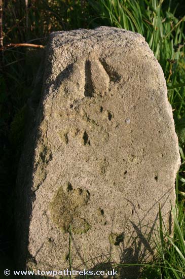
There is no sign of milepost 30 but the milestone is there. It is falling very slowly down the embankment, see if you ca spot it just past Appley bridge. We saw a very strange sight a pair of duck with a brood of tiny ducklings. This is late November but obviously the ducks thought it was early spring.
On the way home we stopped off at Parbold to relocate and photograph the 27 mile milepost. This milepost is in a thick hedge and only visible in winter. After a brief search I found it again and cleared the brambles to photograph it. I also moved the barbed wire from the front to the back of it to stop it wearing the post any more and hopefully to stop the post falling backwards down the embankment. If you ever see a man taking photographs of hedges by the canal, it’s probably me and the mileposts. How nice it would be to clear and paint these mileposts before more are lost.
Monday, November 27, 2006
Monday, November 20, 2006
Canal Walk: Burscough to Rufford
After stops to photograph the Halsall Navvy and to buy sandwiches in Burscough town we arrived at the start of our trek and parked at Ship Inn. The Ship Inn or Blood Tub as it is sometimes known is next to the junction between the Leeds Liverpool mainline and the Rufford branch. The Rufford branch is 7.25miles long linking the main line of the Leeds Liverpool with the River Ribble at Tarleton. I have cycled as far as Marsh Meadow Swing bridge before which was no easy task as the towpath is not maintained in the same way as the main line.
Passing the locks at the top of the branch we soon came to bridge 2A a railway bridge with large passageways either side. Looking up as you pass underneath you will see lots of stalactites hanging down from the stonework above.
It wasn’t long before we came to the first of the Rufford branch mileposts, the reason for the trek. Albert Cliffe in Towpath Walks mentions the 2 and 3 mile mileposts and I was interested to know if they were still there and if they were the same as the main line posts. The first mile post, one mile from the junction, confirmed they were the same design as the mainline. This one had neither plaque left on it so the second question, what the plaques looked like, remained unanswered for now.
At the intriguingly named Germans lock, number 5 of 8, we came across a BWB maintenance boat and a stoppage. The boat inside the lock had a cargo of brand new lock gates and balance beams, unpainted. The water level above this stoppage was low, in contrast with the canal below it where the towpath is level or lower than the canal waters.
Carrying on we came to another lock with another interesting name, chicken lock, number 6.
The Rufford branch is very river-like while the River Douglas which runs alongside is straight and looks very much like a man made canal. As we came to the railway which completes the trio of transport we found milepost number two. Again this one was without markings or any paint. The railway bridge itself is interesting. The canal and railway form a X and the bridge is skewed across the canal.
Another mile on and we came to Rufford Lock and the unpromising sign of a large and obviously new wooden fence. In Towpath Walks Albert Cliffe tells how he met a school party having lunch here and showed them a milepost in the hedgerow. The author asks if the reader can find it too. Sadly, the new marina development seems to have robbed this reader of the chance to find the milepost.
There are two marinas below Rufford lock, one on the left the other on the right. The marina on the left, St Mary’s Marina, although full of boats, has only recently been dug out. The mountain of clay still stands next to the water and the buildings are obviously brand new. The marina on the right, the towpath side, has a nice bridge over its entrance. Both these marinas have plenty of narrow boats in them and while we saw a couple of boats on the move on this cold November day I was left mystified where these boats came from and where they go to if they ever do leave their moorings. We turned around here and headed back to Burscough.
On the way back a stone caught my eye, my first thought was that it was a milestone. Closer inspection showed it to have a benchmark on it which reminded me I had seen this on an old OS map simply marked as a stone with a bench mark. With no walls or bridges nearby perhaps the stone is there just to have the benchmark on it, though the nearby milepost does give cause for speculation that it is a milestone.

For the second part of the walk we drove to St. Mary’s Marina and parked at their tea rooms. Back at the canal we crossed Chapel bridge and continued towards Tarleton. The canal passes through woods by Rufford Old Hall which can be seen through the trees. The towpath becomes very muddy and is quite tricky to get across in places. After the woods the landscape opens out and the canal passes through flat wide farm land. There was a floating platform at work putting in pilings at the canal edge. Fearns swing bridge is not as impressive as its goal-scoring namesake. There was no sign of milepost 4 in the hedge but milepost 5 was there with one plaque still attached. At Strand bridge #10 the towpath ends.

There is an old lock here with no gates, just a narrow bit of canal. Two stone gate posts mark out an over grown plot as being the likely site of a lock keepers house. From the bridge we could see the canal following the old course of the river to Tarlton and the River Lock. With the sun setting we headed back to the car.
Passing the locks at the top of the branch we soon came to bridge 2A a railway bridge with large passageways either side. Looking up as you pass underneath you will see lots of stalactites hanging down from the stonework above.
It wasn’t long before we came to the first of the Rufford branch mileposts, the reason for the trek. Albert Cliffe in Towpath Walks mentions the 2 and 3 mile mileposts and I was interested to know if they were still there and if they were the same as the main line posts. The first mile post, one mile from the junction, confirmed they were the same design as the mainline. This one had neither plaque left on it so the second question, what the plaques looked like, remained unanswered for now.
At the intriguingly named Germans lock, number 5 of 8, we came across a BWB maintenance boat and a stoppage. The boat inside the lock had a cargo of brand new lock gates and balance beams, unpainted. The water level above this stoppage was low, in contrast with the canal below it where the towpath is level or lower than the canal waters.
Carrying on we came to another lock with another interesting name, chicken lock, number 6.
The Rufford branch is very river-like while the River Douglas which runs alongside is straight and looks very much like a man made canal. As we came to the railway which completes the trio of transport we found milepost number two. Again this one was without markings or any paint. The railway bridge itself is interesting. The canal and railway form a X and the bridge is skewed across the canal.
Another mile on and we came to Rufford Lock and the unpromising sign of a large and obviously new wooden fence. In Towpath Walks Albert Cliffe tells how he met a school party having lunch here and showed them a milepost in the hedgerow. The author asks if the reader can find it too. Sadly, the new marina development seems to have robbed this reader of the chance to find the milepost.
There are two marinas below Rufford lock, one on the left the other on the right. The marina on the left, St Mary’s Marina, although full of boats, has only recently been dug out. The mountain of clay still stands next to the water and the buildings are obviously brand new. The marina on the right, the towpath side, has a nice bridge over its entrance. Both these marinas have plenty of narrow boats in them and while we saw a couple of boats on the move on this cold November day I was left mystified where these boats came from and where they go to if they ever do leave their moorings. We turned around here and headed back to Burscough.
On the way back a stone caught my eye, my first thought was that it was a milestone. Closer inspection showed it to have a benchmark on it which reminded me I had seen this on an old OS map simply marked as a stone with a bench mark. With no walls or bridges nearby perhaps the stone is there just to have the benchmark on it, though the nearby milepost does give cause for speculation that it is a milestone.
For the second part of the walk we drove to St. Mary’s Marina and parked at their tea rooms. Back at the canal we crossed Chapel bridge and continued towards Tarleton. The canal passes through woods by Rufford Old Hall which can be seen through the trees. The towpath becomes very muddy and is quite tricky to get across in places. After the woods the landscape opens out and the canal passes through flat wide farm land. There was a floating platform at work putting in pilings at the canal edge. Fearns swing bridge is not as impressive as its goal-scoring namesake. There was no sign of milepost 4 in the hedge but milepost 5 was there with one plaque still attached. At Strand bridge #10 the towpath ends.
There is an old lock here with no gates, just a narrow bit of canal. Two stone gate posts mark out an over grown plot as being the likely site of a lock keepers house. From the bridge we could see the canal following the old course of the river to Tarlton and the River Lock. With the sun setting we headed back to the car.
Tuesday, November 07, 2006
Canal Walk: Blackburn to Cherry Tree
After some map reading we found our way to the carpark of the Wharf pub at Eanam Wharf. This was my first time at the canal in Blackburn and I didn’t know what to expect. I was hoping to see some mills and signs of the much talked about regeneration of the canal area.
Eanam Wharf is a group of warehouses similar to those at Wigan Pier. The main warehouse is used by the Wharf pub and a conference centre, with the short covered section of towpath in front of the conference centre closed to walkers.
At midday on a Sunday I had expected the pub to be busy but we were the only car in the car park. We walked around the back of the well redeveloped warehouses to head out of Blackburn to the west.
The towpath is well maintained and would be great for cyclists although the bushes in some places could do with cutting back. Throughout the whole walk the towpath felt very isolated and quiet with only a few people walking on it, and none of the cheery “hello”s of the last walk.
The canal is above the city; past bridge #103 you get a good view down to the main railway station and across to the streets on the hills opposite. Walkers feel elevated on this section. As we arrived at Blackburn Top Lock we met a boat going down the flight. It was a welcome sight to see people using the canal. There are six locks and they, like the towpaths, have been refurbished recently. Lock 54 is squashed beneath a modern bridge, the canal only just given room to exist by the road builders.
The BWB sanitary station is in part of a group of canalside buildings which have been very nicely redeveloped. There is even a sculpture of a man on a bike, suggesting that the smart towpath is aimed at cyclists.
After the locks and just past bridge 98 I found a large milestone hiding behind some brambles. It was in very good condition considering it was made obsolete by the metal posts put in in 1898. After the milestone is Ewood aqueduct dated 1810 and a long embankment from which you can see the home of Blackburn Rovers.
At 55 miles to Liverpool the only milepost of the day was a sad sight. Both its plaques have been lost and the top is missing, filled with rubbish. The disappointing lack of mileposts was made up for by the finding of another milestone. The old 54 miles to Liverpool milestone is, like the 55 mile stone, in good condition.
At Cherry Tree Bridge #95 we reached the start of George Birtill’s legendary Towpath Treks. There are a lot of new houses which won’t have been there when Birtill took to the towpath. There was no sign of milepost 54, and we turned around at Livesey Hall Bridge #94.
We returned to Eanam Wharf to find the pub still empty. The warehouse here is said to have a milepost (57 miles) inside it but the conference centre made it impossible to look for it.
Subscribe to:
Posts (Atom)