Today looked like it had the potential to either be very nice and sunny or go back to rain and cloud. Luckily by the time we arrived at Tavistock it had decided to be a hot sunny day. The canal in the Meadows was full of ducks being fed bread. Although yesterday it had rained all day the towpath wasnt too bad. The water level in the canal was down, but that exposes the sides of the channel and gives you a chance to see how it was constructed.
It didnt take long to get to the lock and then the junction with the former Mill Hill line. Today we climbed the gate and followed the canal to the left towards the tunnel. Unfortunately the tunnel is in a cutting and was hidden by trees and bushes. I decided not to cross the bridge and go down to the waters edge. It was getting a bit hot and I have seen photos of the tunnel before. Besides I didnt want to explain to the person whose driveway I would have had to walk up what I was doing.
So it was back to the canal and back to Tavistock for a wander about and some lunch and an ice cream.
Showing posts with label Tavistock Canal. Show all posts
Showing posts with label Tavistock Canal. Show all posts
Tuesday, August 11, 2009
Saturday, August 09, 2008
Canal Walk: Tavistock Canal Circular Walk: 6.5 miles
7th August 2008
We planned to do two walks in one day, one either side of the tunnel through Morewellham Down on the Tavistock Canal.
The first part of the day was a walk from the canal wharf in Tavistock along the canal to the junction with the long disused Mill Hill branch, then up to Mill Hill following the route of the canal as much as possible. At Mill Hill Quarry we would then walk back to Tavistock on the public footpath across the fields.
The second part of the day would be a visit to Morewellham Quay and the other side of the canal tunnel, the inclined plane and the quay itself.
We parked in the large car park at the canal wharf in Tavistock. It was £3.00 for up to 4 hours parking, which was plenty of time for the 6.5 mile circular walk we had planned. We wore wellies as the route was expected to be wet, we had had rain and the guides warned that some sections would have water flowing over them. It was a good choice of footwear!
We left the wharf area with its former canal buildings and walked to the Meadows , the public park through which the canal runs. Here the canal looks just like any other water course in a municipal park. There is little to suggest its industrial origins.
Out of the Meadows and onto the main stretch of canal. The canal was full and fast flowing. The rain had given the canal a peaty colour. The last time I walked this section the canal feeder channel was blocked off and the canal water level was low. The canal was built to have a flow to be used to power water wheels and it was clear to see that this canal has a greater flow than most.
There is a wooden pedestrian bridge near to some Bedford cottages, built for the workers in the 1860s. The bridge looks to be a swing bridge but there is no reason for it to open and it looks like it never has. From here the canal leaves Tavistock behind and enters a tree lined section on the valley side above the River Tavy. There is little chance to see anything beyond the canal on either side due to the trees. We saw no other walkers all day and had the canal to ourselves.
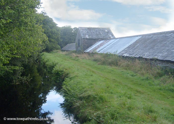
We soon arrived at Crowndale Farm, said to be the birthplace of Sir Francis Drake. There is a gate here but no restriction to public access. This is as far as I had walked the last time I was here. This time we went through the gate and carried on along the grassy towpath. The long low building alongside the towpath at Crowndale Farm was once a warehouse for agricultural produce to be stored awaiting shipment on the canal.

Not far from these buildings is a stone bridge over the canal. It is built from the same local slate as the canal itself. The towpath went under the bridge. So it looks like the bridge is contemporary to the canal’s construction. The most interesting feature of this picturesque bridge is underneath its arch. There is a bright turquoise stain on the stonework caused by copper leaching through, and white stalagmites hanging down.
There is a good view of an early 19th Century farmhouse at Shillamill on the valley floor below. Although the building faces away from the canal it is obviously an impressive building with a large central chimney.
The canal continues to follow its contour with the occasional glimpse of the valley below. The canal passes over a farm track on a stone arch and metal trough dated 1839 (Ref. Walks Around Tavistock).
The Shillamill Viaduct really grabs the attention as it crosses the valley. Built for the LSWR line to Plymouth in 1885 and opened in 1890, it closed in 1968. It is a reminder of the debt the railways owe to the canals. The railway viaduct is similar to the canal viaducts built 90 years before it in the early 1800s. The canal easily passes under one arch of the viaduct and continues on its way.
At some point the canal crosses the valley on a large earth embankment but this is not obvious from the towpath. What is obvious is the black and white wooden lift bridge built in 1998 and already broken. Next to the bridge, at the end of the aqueduct, is a single lock gate. This is a replica of one believed to have been here. If it was just a single gate then the lock could have been used to stop the water flow through the tunnel or to raise the water level upstream during times of low water. Next to the lock and lift bridge is a cottage which was formerly a lock workers cottage. Next to it there looks to have been a canal basin.
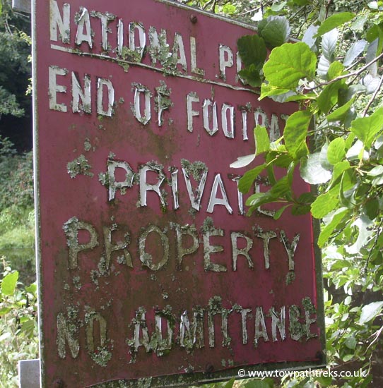
There is a short stretch of canal with a towpath on both sides before we come to the T-Junction. To the left the canal goes a short distance to the tunnel under Morewellham Down. Unfortunately this way is closed to the public and there is a sign telling walkers to keep out. From the junction you cannot see the tunnel entrance, just the canal disappearing into the trees.

So we turned right and headed up the Mill Hill Branch to Mill Hill Quarry. This two mile branch line of the canal was built to bring slate form the quarry down to Morewellham Quay. Unfortunately the quarry chose not to use the canal and it wasn’t long before the canal was replaced with a railroad. The branch was completed in 1819 and only lasted until the 1830s. Today the Mill Hill Branch near the junction is not much more than a damp ditch, further along it is nonexistent. We followed the line of the canal up to the A390, turned right and walked along the busy road, then left into the next lane.
The lanes around here can be quite steep. The high bank and hedge on either side of us made the hot and humid day feel even closer. At the cross roads near Artiscombe there is a former canal bridge which took the canal under the road to the left. It is possible to see it if you are tall enough and look over the hedge. It is a slate bridge and looks to be an original. The back of the bridge has been blocked off and it is now used for storage by the farmer.
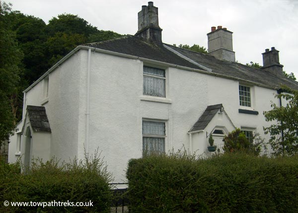
At Mill Hill there is a row of miners’ cottages which follow the line of the former canal. These Bedford Cottages are in six groups of four. Each building is split into four cottages but they are nicely designed and look at first glance look like large semi-detached houses. The building has two front doors at the front for the middle two cottages, and a door on each end for the outer two cottages. Surprisingly they all seem to be in the original configuration and haven’t been knocked through. At the end of the row of houses is a larger building, formerly the canal warehouse which is now converted into a house. The cottage next to it was also a canal building. At the end of the road is Mill Hill Quarry which is still working. There is little left of the canal at Mill Hill.

We walked back to Tavistock following a public footpath across fields. Some of the fields had bullocks in them. They stared at us as we hurried past them. Just how fast can a person run in willies...?
Back in Tavistock we had lunch and visited the Pannier Market where I bought a couple of old postcards. We walked to Abbey Bridge and back to the car park along the River Tavy. The new sluice gate and leaf-lifter are in place; last time I was here they were working on removing the old gate. The new system is large and green and doesn’t do a great job of blending in with its surroundings.
We planned to do two walks in one day, one either side of the tunnel through Morewellham Down on the Tavistock Canal.
The first part of the day was a walk from the canal wharf in Tavistock along the canal to the junction with the long disused Mill Hill branch, then up to Mill Hill following the route of the canal as much as possible. At Mill Hill Quarry we would then walk back to Tavistock on the public footpath across the fields.
The second part of the day would be a visit to Morewellham Quay and the other side of the canal tunnel, the inclined plane and the quay itself.
We parked in the large car park at the canal wharf in Tavistock. It was £3.00 for up to 4 hours parking, which was plenty of time for the 6.5 mile circular walk we had planned. We wore wellies as the route was expected to be wet, we had had rain and the guides warned that some sections would have water flowing over them. It was a good choice of footwear!
We left the wharf area with its former canal buildings and walked to the Meadows , the public park through which the canal runs. Here the canal looks just like any other water course in a municipal park. There is little to suggest its industrial origins.
Out of the Meadows and onto the main stretch of canal. The canal was full and fast flowing. The rain had given the canal a peaty colour. The last time I walked this section the canal feeder channel was blocked off and the canal water level was low. The canal was built to have a flow to be used to power water wheels and it was clear to see that this canal has a greater flow than most.
There is a wooden pedestrian bridge near to some Bedford cottages, built for the workers in the 1860s. The bridge looks to be a swing bridge but there is no reason for it to open and it looks like it never has. From here the canal leaves Tavistock behind and enters a tree lined section on the valley side above the River Tavy. There is little chance to see anything beyond the canal on either side due to the trees. We saw no other walkers all day and had the canal to ourselves.
We soon arrived at Crowndale Farm, said to be the birthplace of Sir Francis Drake. There is a gate here but no restriction to public access. This is as far as I had walked the last time I was here. This time we went through the gate and carried on along the grassy towpath. The long low building alongside the towpath at Crowndale Farm was once a warehouse for agricultural produce to be stored awaiting shipment on the canal.
Not far from these buildings is a stone bridge over the canal. It is built from the same local slate as the canal itself. The towpath went under the bridge. So it looks like the bridge is contemporary to the canal’s construction. The most interesting feature of this picturesque bridge is underneath its arch. There is a bright turquoise stain on the stonework caused by copper leaching through, and white stalagmites hanging down.
There is a good view of an early 19th Century farmhouse at Shillamill on the valley floor below. Although the building faces away from the canal it is obviously an impressive building with a large central chimney.
The canal continues to follow its contour with the occasional glimpse of the valley below. The canal passes over a farm track on a stone arch and metal trough dated 1839 (Ref. Walks Around Tavistock).
The Shillamill Viaduct really grabs the attention as it crosses the valley. Built for the LSWR line to Plymouth in 1885 and opened in 1890, it closed in 1968. It is a reminder of the debt the railways owe to the canals. The railway viaduct is similar to the canal viaducts built 90 years before it in the early 1800s. The canal easily passes under one arch of the viaduct and continues on its way.
At some point the canal crosses the valley on a large earth embankment but this is not obvious from the towpath. What is obvious is the black and white wooden lift bridge built in 1998 and already broken. Next to the bridge, at the end of the aqueduct, is a single lock gate. This is a replica of one believed to have been here. If it was just a single gate then the lock could have been used to stop the water flow through the tunnel or to raise the water level upstream during times of low water. Next to the lock and lift bridge is a cottage which was formerly a lock workers cottage. Next to it there looks to have been a canal basin.
There is a short stretch of canal with a towpath on both sides before we come to the T-Junction. To the left the canal goes a short distance to the tunnel under Morewellham Down. Unfortunately this way is closed to the public and there is a sign telling walkers to keep out. From the junction you cannot see the tunnel entrance, just the canal disappearing into the trees.
So we turned right and headed up the Mill Hill Branch to Mill Hill Quarry. This two mile branch line of the canal was built to bring slate form the quarry down to Morewellham Quay. Unfortunately the quarry chose not to use the canal and it wasn’t long before the canal was replaced with a railroad. The branch was completed in 1819 and only lasted until the 1830s. Today the Mill Hill Branch near the junction is not much more than a damp ditch, further along it is nonexistent. We followed the line of the canal up to the A390, turned right and walked along the busy road, then left into the next lane.
The lanes around here can be quite steep. The high bank and hedge on either side of us made the hot and humid day feel even closer. At the cross roads near Artiscombe there is a former canal bridge which took the canal under the road to the left. It is possible to see it if you are tall enough and look over the hedge. It is a slate bridge and looks to be an original. The back of the bridge has been blocked off and it is now used for storage by the farmer.
At Mill Hill there is a row of miners’ cottages which follow the line of the former canal. These Bedford Cottages are in six groups of four. Each building is split into four cottages but they are nicely designed and look at first glance look like large semi-detached houses. The building has two front doors at the front for the middle two cottages, and a door on each end for the outer two cottages. Surprisingly they all seem to be in the original configuration and haven’t been knocked through. At the end of the row of houses is a larger building, formerly the canal warehouse which is now converted into a house. The cottage next to it was also a canal building. At the end of the road is Mill Hill Quarry which is still working. There is little left of the canal at Mill Hill.
We walked back to Tavistock following a public footpath across fields. Some of the fields had bullocks in them. They stared at us as we hurried past them. Just how fast can a person run in willies...?
Back in Tavistock we had lunch and visited the Pannier Market where I bought a couple of old postcards. We walked to Abbey Bridge and back to the car park along the River Tavy. The new sluice gate and leaf-lifter are in place; last time I was here they were working on removing the old gate. The new system is large and green and doesn’t do a great job of blending in with its surroundings.
Canal Walk: Morewellham Quay
7th August
A Visit to the Morewellham Quay and the Tavistock Canal tunnel.
We drove to Morwellham Quay and parked in their large car park. Their leaflets say the car parking is £2.00 but we weren’t asked for money and didn’t offer any. You can walk around the site and nature trails for free or pay £8.50 to go on the guided trips of the mines, boats and school house. We chose to go for free and just walk around.
The Quay is undergoing a re-vamp at the moment; work was being done on the gardens and quayside. New information signs have recently been put up replacing the old ones which were still lying on the ground.
At the quay there are the remains of the railway which brought ore and other goods from the canal down to the ships waiting at the dock on the River Tamar. The slate sleepers of the railway are still there and further along the line the metal rails are still in place. Between the Malt House and the pub the railway passes by the remains of the incline keeper’s house. The front door opens onto the rails; the laden wagons would have rolled within inches of the front door with no warning.
We followed the brand new granite signposts to the canal incline. Unfortunately the new signs don’t do much more than point you in the general direction. The old blue waymarkers for the former blue route had all been pulled up but were still lying along the route. Past the farm and a field with a small horse and a medium sized horse we came to a path up to the canal. The steps up to the canal are steep, wet and poorly maintained. The canal is without water and overgrown. To the left of the steps is private property and closed to walkers. We went right and followed the path along the overgrown canal.
We knew the tunnel mouth was around here somewhere but couldn’t quite find it straight away. There were no signs saying anything about the tunnels location. At the end of the dry canal is junction with a water channel. The water came from a channel emerging from the trees, it flowed under a sluice gate and into a tunnel obscured by more trees and plants. This tunnel was too small to be the canal tunnel, and is in fact one of the tunnels which takes water from the canal down to the reservoir for the hydro-electric plant. Just as we were about to give up and go I spotted the canal tunnel and its date stone in the trees. It was almost impossible to take a photograph of the tunnel mouth. The tunnel is quite small for a canal tunnel.

We couldn’t find any thing that looked like an inclined plane. To one side of the steps up to the canal there was water flowing from the canal down to the docks. This water was used to power water wheels for pumping drinking water and to operate other machines. The water flows out into the dock and flushed the silt away.
We went back to the quay and had a look at the large lime kilns and the visitor centre of the hydro electric plant.
Hopefully when the renovation work has been completed Morewellham Quay will be worth a visit. The canal did not get a mention in any of the information boards regarding the re-development.
A Visit to the Morewellham Quay and the Tavistock Canal tunnel.
We drove to Morwellham Quay and parked in their large car park. Their leaflets say the car parking is £2.00 but we weren’t asked for money and didn’t offer any. You can walk around the site and nature trails for free or pay £8.50 to go on the guided trips of the mines, boats and school house. We chose to go for free and just walk around.
The Quay is undergoing a re-vamp at the moment; work was being done on the gardens and quayside. New information signs have recently been put up replacing the old ones which were still lying on the ground.
At the quay there are the remains of the railway which brought ore and other goods from the canal down to the ships waiting at the dock on the River Tamar. The slate sleepers of the railway are still there and further along the line the metal rails are still in place. Between the Malt House and the pub the railway passes by the remains of the incline keeper’s house. The front door opens onto the rails; the laden wagons would have rolled within inches of the front door with no warning.
We followed the brand new granite signposts to the canal incline. Unfortunately the new signs don’t do much more than point you in the general direction. The old blue waymarkers for the former blue route had all been pulled up but were still lying along the route. Past the farm and a field with a small horse and a medium sized horse we came to a path up to the canal. The steps up to the canal are steep, wet and poorly maintained. The canal is without water and overgrown. To the left of the steps is private property and closed to walkers. We went right and followed the path along the overgrown canal.
We knew the tunnel mouth was around here somewhere but couldn’t quite find it straight away. There were no signs saying anything about the tunnels location. At the end of the dry canal is junction with a water channel. The water came from a channel emerging from the trees, it flowed under a sluice gate and into a tunnel obscured by more trees and plants. This tunnel was too small to be the canal tunnel, and is in fact one of the tunnels which takes water from the canal down to the reservoir for the hydro-electric plant. Just as we were about to give up and go I spotted the canal tunnel and its date stone in the trees. It was almost impossible to take a photograph of the tunnel mouth. The tunnel is quite small for a canal tunnel.
We couldn’t find any thing that looked like an inclined plane. To one side of the steps up to the canal there was water flowing from the canal down to the docks. This water was used to power water wheels for pumping drinking water and to operate other machines. The water flows out into the dock and flushed the silt away.
We went back to the quay and had a look at the large lime kilns and the visitor centre of the hydro electric plant.
Hopefully when the renovation work has been completed Morewellham Quay will be worth a visit. The canal did not get a mention in any of the information boards regarding the re-development.
Subscribe to:
Posts (Atom)