Pages

Tuesday, December 02, 2008

Liverpool Dock Link


The lock in the dock is looking almost finished. The wooden decking looks very nice but I wonder what it will be like to walk on in the wet or frost.


The south basin is now complete and open for people to look around. It looks very nice but the varnish from the wooden seats has already stained the stonework.

It cant be long before the whole pier head is open.
The museum is nearing completion but it will take some time to fit out the inside and sort of the exhibitions.

Sunday, September 21, 2008

Trekking with Troy

Today Troy went for a walk along the canal from the Saracens Head up to the Halsall Cutting.

Canal Walk Chester

Today I went to Chester to have a look at the postcard fair with the hope of finding some showing the Leeds & Liverpool canal or any interesting scenes of Southport and Liverpool. At the moment we are having some overdue summer days. It was warm and sunny in Chester. I only managed to find one canal postcard at the fair. It shows one of the locks on the Rufford Branch. After the postcard fair I had a pastie by the River Dee then walk to the canal via the Roman Ampitheatre. Down in the cool cutting below the city walls is the old Chester Canal, now part of the Shropshire Union Canal. There are rope marks on the sandstone as the canal bends around following the walls above. The towpath is narrow in places and popular with cyclists. The cutting is also interesting for the geologists as well as canal enthusiasts. The red sandstone has clear bedding with some being folded. Ancient channels cut down into each other.


Northgate Staircase Locks drop the canal down underneath the railway. There are two chambers in the stair case.The lowest set of gates would win an award from the RHS, it is covered with plants. The canal turns right and passes the famous Telfords Warehouse. There is a branch of the canal which locks down to the River Dee. At the jucntion there is a repair dock and boatyard. Over the roving bridge is the north basin. From here the canal is the former Ellesmere Canal up to Ellesmere Port. I turned round here to walk back to the Chester Station along the canal. The canalside pub, the Frog, was packed with people enjoying the sunshine. A little further along I spotted former East End gangster "Mad" Frankie Fraser enjoying the canal. I hope to walk from Ellesmere Port to Chester sometime, its about 9 miles.

Saturday, September 06, 2008

Canal Trip Bates Mill Bridge to Nantwich

Today we were sailing on the Shropshire Union Canal, joining the return trip of the Albatross on its way back from Chester to its home marina in Nantwich. We met the Albatross at Bates Mill Bridge #109. The bridge is typical of the brick bridges on this canal. Next to the bridge is the Shady Oak pub. The pub has a large car park and a caravan site next door. The pub does food and has entertainment, next saturday Elvis will be playing there! On the towpath side of the canal is Bates Mill itself with a mill pond behind Bates Mill Cottage. We set off but only got as far as Wharton Lock where we joined the short queue of boats waiting to go through. One long hire boat crewed by a lot of studenty types would be with us all day.
This canal is the Shropshire Union and the section was origianally the Chester Canal running from Chester to Nantwich. The canal was built to combat the competition Chester had from Liverpool and the Trent and Mersey Canal. It is a wide canal with locks 80ft by 14ft 9inches. The locks have two gates at each end, either wood or metal. The gate paddles on the bottom gates have gears making them easy to wind. Because the locks are wide two boats can use the lock at the same time side by side.
From Wharton Lock you get a good view of Beeston Castle, or rather its remains, high up on a rocky outcrop. There is also a new marker stone here for the Sandstone Trail showing walkers they were 26 km from Frodsham and 29km from Whitchurch. Who chose kilometres over miles? The lock lifted us up 7 feet 8 inches and we set off again. It was about a mile of sailing to the next lock. On the way we past a blue and yellow working boat that had been cutting back the canal side There are some very nice drooping pine trees. The canal shop by Beeston Brook Bridge #107 was always a popular place to stop when we passed by on family hoidays. Beeston Iron Lock is unique in my experience. As its name suggests it is made of iron. The sides of the lock are iron clad and the gates are iron. The lock was constructed in 1828 and looks the height of Industrial Revolution modern design. Rivetted, flanged iron plate was used rather than brick or stone because of the "running sand" which had caused the lock to collapse in 1787. Up another 7 feet and on to the next lock Beeston Stone Lock, taking us up 8 feet 6 inches.

I had forgotten both of my cameras today so had borrowed one from a fellow member of crew. It was while pushing open the gate on the stone lock that I leant on the camera and broke the LCD screen. The camera still takes photos but the screen is blank except for a blurred corner. Not a great way to repay a favour!At the stone lock there is a small round brick building with a central chimney. A charming little building and we are lucky to still have them. There is another at the next lock, Tilstone lock which lifts us up 9 feet 8 inches.Throught the lock and we came to a sunked Dawncraft. its alwas sad to see a sunken boat, especially a little GRP cruiser. These boats were built for days out and weekends of fun on the canals, they lack the pretentions and luxury of the modern narrowboats that are more about flat screen TV and walk in shower rooms than messing about in boats. The locks at Bunbury at a staircase two rise. That is two lock chambers sharing a set of gates in the middle. It takes a bit of thinking about to ensure the water is in the right chamber at the right time. You dont want two locks of water in one lock chamber. To make things interesting we had a boat coming down as we were going up. We passed in the middle and it all went well. The sky was looking greyer but that didnt stop us from having a choc ice from the canal shop by the locks.We passed by some more Dawncraft cruisers that looked like they were on their way to be crushed. Part of the ethnic cleansing of the canals.The temperature dropped and the rain started. I retired inside to look at the scenery in the dry. The good thing about a cruiser is you can sit out and steer in the rain without looking like a drown rat as some narrowboat owners do. We passed one narrowboat that had a very small silly one man rain hood. If you dont like the rain dont buy a narrowboat and sail in England. We passed the junction with the Middlewich Branch, there was a warehouse that crossed over the canal here. There are the remains of a lock here too, maybe it was just for controlling traffic and tolls but there are niches for two sets of gates. Just after the Olde Barbridge Inn(e) we met the studnets trying to accomplish what looked to be a reverse mooring manouver. They had managed to block off the canal and were going no where fast. But on the canal one has to be patient.The rain got worse and by the time we reached the moorings at Nantwich it was proper rain not just the fine rain that soaks you. We drove back to the Barbridge for tea, we had the fish and chips, the chicken curry and 10oz gammon. Big portions and reasonably priced. Then we drove back to the Shady Oak to pick up my car and went home.It was nice to see the canal from a boat for a change and it is good to get back to carrying a windlass and winding some paddles.

Saturday, August 23, 2008

Canal Pub: The Ship Lathom

In 2002 Ajmail and Sudarghara Dusanj saved Liverpool’s Cains brewery from closure when they acquired it from the Danish Brewery Group. The brewery had previously been owned by Whitbread and the site was once owned by Higsons whose name appears in the Victorian terracotta on the building.
In May 2007 Cains Beer Company was created when Robert Cain & Co Brewery acquired Honeycombe Leisure in a reverse takeover. Honeycombe Leisure was a pub estate with about 100 pubs. The take-over was funded by the Bank of Scotland who provided £40million in total, £30million in a loan and £5million working capital and £5million for refurbishing pubs.
The new company had an estate of about 115 pubs, most of which were leasehold. The Dusanj brothers own 10 of the pubs Cains Beer Company leased, with 44 others being owned by Punch Taverns and Admiral Taverns. The company owns some 26 freehold pubs.
The cost to the company of servicing the interest on its debt to the Bank of Scotland rose from £66,000 a year ago to £1.2million in the latest 6 months. The Cains Beer Company announced half-year losses of £4.6million this year and lost the confidence of its backers. With debts of between £40 and £45 million the company went into administration. PricewaterhouseCoopers LLP were appointed as joint administrators.
The brewery itself is owned by a company belonging to the Dusanj brothers. The site was leased to the Cains Beer Company for £0.5million per year.
The brewing and canning side of the business is likely to be sold to either the Dusanj brothers or to Marstons. The brewery produced mostly own-label beer for supermarkets etc (58%), also contract brewing (14%) and the rest was Cains beer. Cains beer was increasingly popular and appeared on the shelves of major supermarkets. Cains beer was a sponsor of the Tall Ships and a part of Liverpool’s Capital of Culture year.
Most of the pubs leased by Cains Beer Company will be returned to the pub groups who own them. PricewaterhouseCoopers has started closing down pubs it says are making a loss. The freehold pubs are to be sold off. The Cains Beer Company employed 900 people in pubs and 100 in the brewery.
The Ship Inn or Blood Tub at Lathom near the top lock of the Rufford Branch was leased by Cains Beer Company. PricewaterhouseCoopers have closed it down and returned it to its owners Punch Taverns Ltd. Its manager of the last six years, Les Bentham has had to tell his staff they have lost their jobs. Punch Taverns offered him the chance to stay on in the pub, which is his home as well as his business but he cannot afford the £10,000 deposit and £2,500 a week rent the want.
The former landlord said that trade had declined since Cains took over the pub, replacing real ale with their own Cains beers. Reviews of the pub on towpathtreks.co.uk were all bad since the take over. All reviewers lamented the once great pub and blamed Cains for the drop in quality. However to be fair to the Cains Beer Company many of the criticisms were to do with the way the pub was run and its cleanliness rather than the beer on sale.
Punch Taverns, owners of the Ship Inn are looking for another licensee to take over running the Ship Inn. Hopefully the pub will re-open soon and be great once again.
I hope that the Dusanj brothers can buy the Cains brewing business and carry on producing popular good quality beers. Hopefully this time they wont feel the temptation to jump into the deep end of the pub owning business.

Saturday, August 09, 2008

Canal Walk: Bude Canal

The weather forecast for today was bad but we decided to drive to Bude anyway. We parked near the beach in a pay and display car park. The rain never stopped but did ease off enough to tempt us out of the car. There are what look like WW2 concrete defences around the edge of the carpark along the sand dunes. We walked over the sandy beach to the River Neet and the canal's Sea Lock. There were people surfing in the sea, the bay is sheltered by a break water, part of the original canal plan. Bude has some of the worst sea water quality in the UK.The lock gates on the sea lock are huge. Despite this one had become dislodged during a storm recently and had to be rehung. A shotgun was one of the items recovered while the canal was drained to do this. The locks stonework is very solid. The mooring rings look like they have been gven steroids too. Everything looks like a regular canal lock but on a larger scale. Along side the lock is a slope down to the beach via a small bridge over the River Neet. On the slope are the remains of a railway. Sand was brought up from the beach on the railway on horse drawn wagons. It was then tipped into barges to be taken inland by canal to be used as manure on the fields.

There are quite a few boats in the lower wharf including some rowboats and pedalos for hire. Pleasure boating on the Bude Canal has been popular for over 100 years. Maybe next time we will explore the canal by boat, weather permitting.The first bridge we came to was Falcon Bridge next to the Falcon Inn. The bridge replaces a large swing bridge. There isnt much headroom under the bridge which stops most boats entering the upper wharf and using the barge canal beyond. Next to Falcon Bridge is the old lifeboat house, now a private home. Nearby is a converted canal warehouse, now apartments.There were lots of dogs walkers braving the rain on the towpath. We had decided to just walk the first mile of the barge canal but we didnt even make it that far. The towpath was closed off and there was no way around. Defeated by the Bude Canal we walked back through the nature reserve which borders the canal. There were some ducks, a heron and a cormorant drying its wings on a rooftop. At the lower wharf there is a heritage centre which has some expenisve books and guides to the Bude Canal. Back at the sea lock the rain was getting worse so we went back to the car.Hopefully next time the sun will be shining and the towpath open.

Canal Walk: Tavistock Canal Circular Walk: 6.5 miles

7th August 2008

We planned to do two walks in one day, one either side of the tunnel through Morewellham Down on the Tavistock Canal.
The first part of the day was a walk from the canal wharf in Tavistock along the canal to the junction with the long disused Mill Hill branch, then up to Mill Hill following the route of the canal as much as possible. At Mill Hill Quarry we would then walk back to Tavistock on the public footpath across the fields.
The second part of the day would be a visit to Morewellham Quay and the other side of the canal tunnel, the inclined plane and the quay itself.

We parked in the large car park at the canal wharf in Tavistock. It was £3.00 for up to 4 hours parking, which was plenty of time for the 6.5 mile circular walk we had planned. We wore wellies as the route was expected to be wet, we had had rain and the guides warned that some sections would have water flowing over them. It was a good choice of footwear!
We left the wharf area with its former canal buildings and walked to the Meadows , the public park through which the canal runs. Here the canal looks just like any other water course in a municipal park. There is little to suggest its industrial origins.
Out of the Meadows and onto the main stretch of canal. The canal was full and fast flowing. The rain had given the canal a peaty colour. The last time I walked this section the canal feeder channel was blocked off and the canal water level was low. The canal was built to have a flow to be used to power water wheels and it was clear to see that this canal has a greater flow than most.
There is a wooden pedestrian bridge near to some Bedford cottages, built for the workers in the 1860s. The bridge looks to be a swing bridge but there is no reason for it to open and it looks like it never has. From here the canal leaves Tavistock behind and enters a tree lined section on the valley side above the River Tavy. There is little chance to see anything beyond the canal on either side due to the trees. We saw no other walkers all day and had the canal to ourselves.
We soon arrived at Crowndale Farm, said to be the birthplace of Sir Francis Drake. There is a gate here but no restriction to public access. This is as far as I had walked the last time I was here. This time we went through the gate and carried on along the grassy towpath. The long low building alongside the towpath at Crowndale Farm was once a warehouse for agricultural produce to be stored awaiting shipment on the canal.

Not far from these buildings is a stone bridge over the canal. It is built from the same local slate as the canal itself. The towpath went under the bridge. So it looks like the bridge is contemporary to the canal’s construction. The most interesting feature of this picturesque bridge is underneath its arch. There is a bright turquoise stain on the stonework caused by copper leaching through, and white stalagmites hanging down.
There is a good view of an early 19th Century farmhouse at Shillamill on the valley floor below. Although the building faces away from the canal it is obviously an impressive building with a large central chimney.
The canal continues to follow its contour with the occasional glimpse of the valley below. The canal passes over a farm track on a stone arch and metal trough dated 1839 (Ref. Walks Around Tavistock).
The Shillamill Viaduct really grabs the attention as it crosses the valley. Built for the LSWR line to Plymouth in 1885 and opened in 1890, it closed in 1968. It is a reminder of the debt the railways owe to the canals. The railway viaduct is similar to the canal viaducts built 90 years before it in the early 1800s. The canal easily passes under one arch of the viaduct and continues on its way.
At some point the canal crosses the valley on a large earth embankment but this is not obvious from the towpath. What is obvious is the black and white wooden lift bridge built in 1998 and already broken. Next to the bridge, at the end of the aqueduct, is a single lock gate. This is a replica of one believed to have been here. If it was just a single gate then the lock could have been used to stop the water flow through the tunnel or to raise the water level upstream during times of low water. Next to the lock and lift bridge is a cottage which was formerly a lock workers cottage. Next to it there looks to have been a canal basin.
There is a short stretch of canal with a towpath on both sides before we come to the T-Junction. To the left the canal goes a short distance to the tunnel under Morewellham Down. Unfortunately this way is closed to the public and there is a sign telling walkers to keep out. From the junction you cannot see the tunnel entrance, just the canal disappearing into the trees.

So we turned right and headed up the Mill Hill Branch to Mill Hill Quarry. This two mile branch line of the canal was built to bring slate form the quarry down to Morewellham Quay. Unfortunately the quarry chose not to use the canal and it wasn’t long before the canal was replaced with a railroad. The branch was completed in 1819 and only lasted until the 1830s. Today the Mill Hill Branch near the junction is not much more than a damp ditch, further along it is nonexistent. We followed the line of the canal up to the A390, turned right and walked along the busy road, then left into the next lane.
The lanes around here can be quite steep. The high bank and hedge on either side of us made the hot and humid day feel even closer. At the cross roads near Artiscombe there is a former canal bridge which took the canal under the road to the left. It is possible to see it if you are tall enough and look over the hedge. It is a slate bridge and looks to be an original. The back of the bridge has been blocked off and it is now used for storage by the farmer.
At Mill Hill there is a row of miners’ cottages which follow the line of the former canal. These Bedford Cottages are in six groups of four. Each building is split into four cottages but they are nicely designed and look at first glance look like large semi-detached houses. The building has two front doors at the front for the middle two cottages, and a door on each end for the outer two cottages. Surprisingly they all seem to be in the original configuration and haven’t been knocked through. At the end of the row of houses is a larger building, formerly the canal warehouse which is now converted into a house. The cottage next to it was also a canal building. At the end of the road is Mill Hill Quarry which is still working. There is little left of the canal at Mill Hill.

We walked back to Tavistock following a public footpath across fields. Some of the fields had bullocks in them. They stared at us as we hurried past them. Just how fast can a person run in willies...?
Back in Tavistock we had lunch and visited the Pannier Market where I bought a couple of old postcards. We walked to Abbey Bridge and back to the car park along the River Tavy. The new sluice gate and leaf-lifter are in place; last time I was here they were working on removing the old gate. The new system is large and green and doesn’t do a great job of blending in with its surroundings.

Canal Walk: Morewellham Quay

7th August

A Visit to the Morewellham Quay and the Tavistock Canal tunnel.

We drove to Morwellham Quay and parked in their large car park. Their leaflets say the car parking is £2.00 but we weren’t asked for money and didn’t offer any. You can walk around the site and nature trails for free or pay £8.50 to go on the guided trips of the mines, boats and school house. We chose to go for free and just walk around.
The Quay is undergoing a re-vamp at the moment; work was being done on the gardens and quayside. New information signs have recently been put up replacing the old ones which were still lying on the ground.
At the quay there are the remains of the railway which brought ore and other goods from the canal down to the ships waiting at the dock on the River Tamar. The slate sleepers of the railway are still there and further along the line the metal rails are still in place. Between the Malt House and the pub the railway passes by the remains of the incline keeper’s house. The front door opens onto the rails; the laden wagons would have rolled within inches of the front door with no warning.
We followed the brand new granite signposts to the canal incline. Unfortunately the new signs don’t do much more than point you in the general direction. The old blue waymarkers for the former blue route had all been pulled up but were still lying along the route. Past the farm and a field with a small horse and a medium sized horse we came to a path up to the canal. The steps up to the canal are steep, wet and poorly maintained. The canal is without water and overgrown. To the left of the steps is private property and closed to walkers. We went right and followed the path along the overgrown canal.
We knew the tunnel mouth was around here somewhere but couldn’t quite find it straight away. There were no signs saying anything about the tunnels location. At the end of the dry canal is junction with a water channel. The water came from a channel emerging from the trees, it flowed under a sluice gate and into a tunnel obscured by more trees and plants. This tunnel was too small to be the canal tunnel, and is in fact one of the tunnels which takes water from the canal down to the reservoir for the hydro-electric plant. Just as we were about to give up and go I spotted the canal tunnel and its date stone in the trees. It was almost impossible to take a photograph of the tunnel mouth. The tunnel is quite small for a canal tunnel.

We couldn’t find any thing that looked like an inclined plane. To one side of the steps up to the canal there was water flowing from the canal down to the docks. This water was used to power water wheels for pumping drinking water and to operate other machines. The water flows out into the dock and flushed the silt away.
We went back to the quay and had a look at the large lime kilns and the visitor centre of the hydro electric plant.
Hopefully when the renovation work has been completed Morewellham Quay will be worth a visit. The canal did not get a mention in any of the information boards regarding the re-development.

Saturday, August 02, 2008

Canal Pub Lunch: The Ship Haskayne

Today we had a quick pub lunch and walk at the Ship Haskayne. The pub was quiet when we got there at lunchtime, the staff outnumbered the customers. We had a ham sandwich and bacon/chicken/brie panini both with chips and salad. The sandwiches were okay, the chips were nice. I didnt get chance to try the beer but the bar had a good selection of Southport beers.
The food came quickly and the staff were friendly.
http://www.towpathtreks.co.uk/llc/pub_info_display.asp?ino=03

After lunch we walked up to the cutting. There were three boats on the move and 4 cyclists and some dog walkers. We identified a few wildflowers for the website:
http://www.towpathtreks.co.uk/About/canal_wildlife.html
There were lots of little fish in the canal and some teenage ducks on the bank.

Wednesday, July 30, 2008

Cains in Trouble

Liverpool brewers Cains are in financial trouble, there last figures showed a loss of £4.6m and they are waiting to hear from their bank. With their future in doubt it is a concern for the pubs they recently took onboard. The Ship or Blood Tub at Burscough is a Cains pub I believe.
Added to the Cains problems is the news that the Running Horses has recently shut and is up for sale.
The rise in petrol prices and the governments continued attacks on public houses must make life hard for landlords, especially those at canal pubs that are more remote from the usual town pub.
The number of pubs on my pub guide could be dropping again...

http://www.towpathtreks.co.uk/LLC/canal_pub_guide.html

Saturday, July 19, 2008

In Loving Memory

My sometimes fellow towpath trekker Honey is no longer with us. She holidayed on board the Albatross and found it hard getting on and off but enjoyed the towpaths. She preferred the Ainsdale sand dunes to the canals. We had some nice walks and some slow toddles in the last few years. I will miss her lots.

Monday, July 07, 2008

Canal Visit: Halsall

Yesterday we had hoped to go to the canal for a walk but the weather was so changable we couldnt tell whether it was going to pour down or have a heat wave. We headed towards some blue sky and away from the huge black cloud with mini tornados under it. We parked at Halsall by the Halsall Navvy. It was raining a bit and on the horizon towards Ormskirk the sky was black and it must have been pouring down. We only managed a very short walk but we saw some interesting flowers on the towpath: tufted vetch, hemp-agrimony and the usual yellow flowers that could be any one of many types!
It was a shame we didnt have more time on the towpath but we at least got some fresh air and used my new field guide to flowers. Even with the D SLR its tricky to get the flowers in focus. There were quite a few people on the towpath and the Saracens Head looked busy.

Saturday, June 21, 2008

Canal Walk Leeds

Monday 16th June

After waking up far too early and then dozing for too long afterwards we went to the Riveresque Cafe by Leeds Bridge for breakfast. We had the small breakfast which was 2 eggs, 2 bacon, 2 sausage, 2 toast and beans, for £3.95 a bargin compared tot he large breakfast for £5.95 which just had mushrooms and tomatoes.
After breakfast we checked out of the hotel and left our luggage at reception. Apart from trying to charge me twice for the first night the hotel was very good. I would recommend the Jurys Inn to anyone going to Leeds for the canal or for the Royal Armouries. Just bring sandwiches...The hotel is at Brewery Wharf justa couple of minutes from the Arouries or the city centre. I could even see the lock keepers tower from our room.

We had until 5:10pm in Leeds so we went to the Royal Armouries. The museum naturally has an impressive range of weapons but also covers hunting, falconry and the fight against knife and gun crime. the most impressive display are the swords, bayonettes and guns in the stairwell.
The Armouries saw us through till 12:00. I had a quick walk up to the Aire and Calder and looked around the corner to see what it looked like heading out of the city. A future walk I think.
For lunch we went up tot he Headrow and had a partially cooked burger in a pub. I did have some Saltaire Blonde beer though.
After a bit of shopping we got our luggage and had one last look at the River Lock and the end of the Leeds & Liverpool Canal.

Leeds was disappointing for food but there are some nice pubs for drinkers. It has some great shopping malls but the Victorian arcades are the best feature. Leeds, like Liverpool is developing its waterfront. Leeds is luckier in that its canal meets the River Aire and so was not filled in. Leeds has a nice waterfront area with luxury apartments and hotels being built while Liverpool has a car park where the canal basin once was.

I enjoyed my weekend in Leeds and it was good to finish the canal and see the end of the line.

Thursday, June 19, 2008

Canal Walk: Shipley to Leeds 13 miles

Sunday 15th June

After a quick breakfast at the hotel we headed off to the station. There was some confusion about which one of the two trains on platform was the one we wanted but at 8:40 we got on the Morecambe train and set off to Shipley. The trains route follows the canals and from the train I managed to spot a half milepost on the towpath. The railway cheats and goes through a tunnel where the canal follows the contour. The trip took about 15 minutes and Shipley was the first stop after the tunnel.
Shipley Station is triangular with three platforms and large free car park in the centre. Not far from the station we got onto the towpath at bridge #207C. We had already walked on the towpath at Shipley but not very far.
I paused at Dock Swing bridge #209, after the former junction with the Bradford Canal. I have some old photos of the canal in Shipley taken in the 1960s. One of the photographs shows Dock Swing bridge, not much has changed but a new building has recently been added to the view.

With Shipley quickly left behind us the canal enters Buck Wood. The majority of the walk was tree lined and very quiet. The water was crystal clear and still. It looked more like a mill pond than a canal, there were water lilies and pond weed and even pond skaters on the surface. The canal by the towpath was very shallow, not suitable for mooring boats. The clear water meant we could spot fish as easily as spotting birds or plants. There were lots of small fry, some young perch, a baby pike and a huge carp, along with some other unidentified fishes.
Most of the bridges on this bit of canal are swingbridges. There are only a few of the typical stone L&L bridges. there are quite a few locks, evenly spaced out along the walk. They come in rises, either 2 or 3 rises, or indiviually. The use of rises (locks joined together, sharing gates) shows that this stretch is one of the old bits of canal. Elsewhere at Greenberfield the rises were replaced by individual locks to save water.
Other than brief brushes with civilisation at Rodley and Apperley Bridge the canal is flanked by trees and fields with some nice views. At Kirkstall you can see across the fields to the ruins of Kirkstall Abbey.
There are plenty of mileposts on this stretch, a sign at the end of the walk explained that the posts in the last 10 miles of the canal were replaced or refurbished in the 1990s. Even so we couldn't find milepost 117 despite it being on the 2005 OS map.
The towpath is very popular with cyclists. It is one of the national cycle routes. While it is good to see so many people enjoying the canal we did seem to spend a lot of time looking over our shoulders or stepping out of the way of speeding bikes. The cyclists outnumbered the walkers by 10:1. There were some people fishing and a group in inflatable kayaks. We only saw 4 canal boats on the move all day and they were just narrowboats.

Two miles from the end of the walk at Armley we stopped off to visit Armley Mill and its industrial museum. It was £3.00 to get in and we were shown the mill house which is set up to show how the rich mill owner and a poor mill worker would have lived. The museum has looms and spinning machines, engines, a display about cinema and cameras. It was interesting but the whole museum is a bit run down now and obviously hasn't had any money spent on it in along time. There were only half a dozen people looking around it while we were there.

From Armley it is just one and three quarter miles to River Lock and the end of the Leeds & Liverpool Canal. The last bit of the canal passed by quite quickly. At Oddy Lock we heard sirens, a reminder that the city was close by. From here on the city started to make itself known. There are more buildings, some had past links with the canal. The railways grew closer, crossing the canal on high bridges or just the remains of former bridges from disused lines. The skyline looking towards the city would be unrecognisable to anyone from 10 years ago let alone 250 years ago. New buildings are growing up all the time though I suspect they wont last as long as the few remaining chimneys have done.
As the canal, railway and River Aire draw closer and the city engulfs them all there are still some interesting wildflowers growing on the towpath.
At River Lock there are new buildings being constructed on the side of the basin, on the former car parks. There is little fanfare to mark the end/beginning of the Leeds & Liverpool Canal. Just a faded welcome sign. With just 4 boats on the move on a sunny summer Sunday it seems that this end of the canal is just as quiet as the Liverpool end.
As we walked back to the hotel the clouds became darker and it started to rain.

Later on we went out for some food and a drink. Coming from Liverpool the Adelphi pub sounded the right sort of place for us. It is next to Leeds Bridge on the River Aire/Aire and Calder Navigation. It is a once grand Edwardian pub/gin palace similar to the Vines pub in Liverpool. The pub has etched windows and some fine tiles and woodwork. I had a strong cider, 7.5%, but the Butcombe Blonde was nicer. Unfortunately they had run out of Sunday roasts by the time we got there so we had to look elsewhere for food and ended up in a noodle bar. We walked up Kirkgate, past the Palace pub, said to have 12 real ales, and up to Crown Point bridge. Over the bridge we visited Clarence Dock which is surrounded by new buildings including the Royal Armouries. The area was quiet as we walked back to the hotel.

Tuesday, June 17, 2008

Canal Walk: Leeds

This weekend I completed my walk from Liverpool to Leeds, from Old Hall Street and Pall Mall to River Lock and the Aire and Calder Navigation. Strolling, walking and trekking 127.25 miles along the Leeds & Liverpool Canal, albeit in different stages over a couple of years.
Saturday 14th June
We left Liverpool at 9:22 am on Saturday from Lime Street Station. From the train I saw the canals at Castlefield in Manchester, underneath the railway arches where I spent a holiday once years ago. As the train neared Huddersfield there was another narrower canal probably the Huddersfield Narrow Canal.
We arrived in Leeds at 11:09, less than 2 hours travel time and a few days quicker than a fly-boat.
Realising I didn’t know Leeds and didn’t have a map other than my Nicholson Guide we went to the Tourist Information centre at Leeds Station and picked up a free map of the city centre. My research into the pubs of Leeds hadn’t turned up much but one put did come recommended, Whitelocks (formerly known as the Turks Head) . The pub has a good selection of beers and has some nice tiles in its compact narrow interior. The pub and the yard with it are examples of the inns built in the back gardens of original burgage plots. Burgage plots were the long thin plots of land given to merchants and tradesmen to build their houses and shops on. Many sold land to the rear and pubs and other businesses were built with access to the main street via an alley at the side of the merchant house. Sadly the food in the pub isn’t much to write home about and more than one customer left without finishing their food. A disappointing start to the weekend for us.

After checking in to the Jurys Inn hotel at Brewery Wharf we noticed there was a waterside festival on. I think anyone turning up based on the promise of an arts market and other attractions might have felt a little short changed.
I decided to do a little reconnaissance and find River Lock and the Leeds & Liverpool Canal. I knew the canal terminus was near the station so we started there but only found the River Aire and was above it not alongside it. After a bit of wandering about I found myself on Victoria Bridge over the Aire. A group of youths were settling down with a crate of beer on one side so I walked over to the other side and found the original 1770s canal warehouse now an expensive restaurant called the Olive Press. On the other side is River Lock, lock number one of the Leeds & Liverpool Canal. We walked along the canal to the last bridge of the Leeds & Liverpool: Office Lock Bridge #226 and looked over to see Office Lock. A way off was the last milepost. Next to the bridge is the little office building which gives the lock its name. Unfortunately someone had parked in front so I couldn’t get a photo then. I just hoped the weather was okay when I came past next time. I did get a photograph of one of the two canal company notices on the bridge. They refer to the Motor Car Acts of 1896 and 1903 and give the address of the canal company as Pall Mall, Liverpool.
We went back to the hotel along the River Aire and took some photographs of Victoria, Leeds and Crown Point Bridges. We bought sausages and chips from a boutique chippy, Battered, but sadly they were horrible. Any chippy making its customers wait so long for such bad chips would go out of business anywhere else; luckily for Battered they have a captive and ever changing cliental at the nearby hotels.

Sunday, May 18, 2008

Canal Walk: Burscough

After lunch we parked by Burscough Bridge. I took some photos of the new street furniture in Burscough and of the Waterfront pub. We walked up to the Farmers Arms, taking photos of the Slipway on the way. As we walked we had a look at the wild flowers on the towpath. Most were known to us but there were plenty we needed to look up.
I was surprised to see that the half mile and 22 mile post have been painted. Some one has been busy with the paintbrush!
At the Farmers Arms a couple were making hard work of operating the swingbridge. Luckily for the waiting motorists I was passing and pointed out the bridge wouldnt do anything while the barriers were open. On the way back to Burscough I did my second good turn by freeing an anglers line from the towpath.
The towpath was busy with walkers and it is always good to see boats on the move.

Canal Pub Review: Ring O' Bells

Although I have walked passed the Ring O' Bells pub many times I have never set foot inside it until today. We parked in the pubs car park. Rather surprisingly for a Sunday lunchtime the pub was almost empty. There was plenty of choice of where to sit in the large dining area. We sat by the window over looking the fied with the sheep. The sheep have very impressive horns and look prehistoric. There is an outdoor and indoor play area for the children.
At the bar there were 3 or 4 draught beers including Bishops Finger. I stuck with a coke thanks to the car.
There are a number of menus at the Ring O Bells. The main menu has all the usual meals, with steaks for less than £10.00. There is also a Curry Menu, a Childrens Menu and a snack menu. The snack menu has sandwiches for £3.50 to 3.95 or hot baggettes for £3.95 to £4.95 and jacket potatoes.
We ordered a prawn sandwich and a jacket potato with prawns. The food didn't take long to arrive and was generously piled with prawns.
After eating we left the pub to find two large Old English Sheep dogs on the sloping roof of the pub.
The pub was okay and I think it would be a great place for a sumer time drink.

Monday, May 12, 2008

Canal Collection

I have recently started collection canal memorabilia. Today I got a couple of pre-war postcards of the canal in Maghull. I also got an invoice and letter from the Leeds Liverpool Canal Company regarding transportation of olive oil from Liverpool to Bradford in 1919. Hopefully I will put some of these items on www.towpathtreks.co.uk when it is relaunched.

Canal Walk: Liverpool Circular

It was a sunny Sunday today, well at least until the barbeque was lit this afternoon. I wanted to walk the route of the third of my walks I have written for people to download from www.towpathtreks.co.uk. I wanted to check the walk was easy to follow and see how long it took. And if there was anything interesting along the way I could add it in.
The walk starts at Old Hall Street but we parked at the large car park by the Echo Area. The aim was to get back to the car within 2 hours to save me paying another £2. I had thought about parking on the road but opted for the car park.
We walked from the Albert Dock to Old Hall Street. The Pierhead was busy. Here were lots of football fans about, blues, reds, and quite a few Newcastle fans here for the last game of the Premiership season.
Old Hall Street has seen a lot of change recently. There are new office buildings which makes the small brick building that is the remains of Clarkes Basin look all the more anachronistic. As last nights hen party got into their taxi we looked at the information panels on the girder out side the hotel. At the end of Old Hall Street we turned right on to Leeds Street. Leeds Street was widened and some of the canal terminus buildings were lost as a result. A car show room now stands where the canal headquarters once were. I had a quick look behind the canal warehouses. The basin is now a carpark but the large stones of the edge of the basin are still there. Back on Pall Mall a woman was clearing up the glass from her broken car window. I was glad I parked in the car park. Past the remains of the boatmen’s mission we turned right into Chisenhale Street and over the old canal bridge which remains in good condition considering the canal underneath it was filled in 40 years ago. There are buildings on both sides of it so unless there is a disaster there is slim chance of the canal being restored.
Over the bridge it was a short walk up Chisenhale Street then left onto Vauxhall Road. The Green Man pub is still standing. It featured in the last episode of the Boys from the Blackstuff. The Boys drink there before crossing the road and walking through the Tate and Lyle works as they are being demolished. These days the Eldonian Village estate is over the road. We went across the carpark of the village hall and down to the towpath. Eldonian Village was built for a community. Mothers were actually stood talking over the garden fence while their children played on the towpath. This is a redevelopment that has worked. Compare this to the empty blocks of luxury apartments built along the Regents Canal.
We walked down the Stanley Dock branch, through the doorway and across Great Howard Street to the Heritage Market. The market has had trouble because of the large amounts of fake goods sold there. They claim to have stopped this and are hoping to promote the market as an attraction. I chose not to buy a DVD of the new Indiana Jones film (not yet out at the cinema) and walked through the market to exit on the other side.
We walked up the dock road to Princes Dock. There are two new temporary bridges across the dock while the old bridges are changed to allow boats to pass under them. HMS Bulwark was visiting the new landing stage and drawing a big crowd. The new canal lock is nearly finished and you can see where the gates will go. The canal link across the front of the Three Graces looks close to completion. We managed to get back to the car with a few minutes to spare. The whole walk took about 2 hours without any stops at quite a quick pace.

Friday, May 09, 2008

Canal Pub Review: Saracens Head Halsall

As it was a sunny summer evening and with a birthday to celebrate it seemed a good opportunity to go to the newly refurbished Sarcacens Head at Halsall.
From the outside not too much has changed. The pub now has a modern sign and some nice new wooden seating. The pub is lucky to have a large car park at the back so there was no problem finding somewhere to park. The pub re-opened 8 weeks ago and there are still signs that it is not quite finished yet, not least the fact that the main doors were still being fitted when we arrived.
Once you go inside you can see where the money was spent. The pub has been completely refurbished in a very classy modern style. There are some black and white photos of the old pub and canal scenes but there has been no attempt to recreate a country pub.
There were two menus, a bar menu and the dinner menu. the bar menu is available until 8pm, later than some pubs. We had the fish and chips, the gammon and a New York burger. When the food arrived any fears that they would be trendy (ie small) portions were gone. The food was hot, it hadnt been hanging around in the kitchen. The prices are good for that class of establishment, much better than the Blackburne Arms in Liverpool. We managed to fit in some deserts too, the apple crumble (served in a cup!) was hot and had plenty of apple.
There were a couple of negatives, we had started to look at our watches waiting for the food and the waitresses need a bit of practice and they need to smile more.
I recommend evryone to see this pub while it is newly refurbished and enjoy and meal and a drink while you are there.

Monday, May 05, 2008

Canal Walk: Halsall to Scarisbrick

Bank Holiday Monday and it isn't raining so it was off to the canal for towpath trek. Its been a while since I have had a walk on the canal and it was nice to be back.
We parked on the small car park next to Halsall Warehouse Bridge over the canal from the Saracens Head pub. We walked towards Scarisbrick to see how the new marina was progressing. The sky was grey and it was warm and a bit humid. There were lots of people out walking, fishing, and cruising.
The blossoms and hedgerow flowers were out and attracting butterflies.
The mysterious milepost painter has visited milepost 19 and pruned back the hedge and painted the milepost. Its now easily visible, before it was camouflaged.
Approaching the Red Lion caravan place by Scarisbrick bridge there is a new fence being built on the towpath. The field behind it will soon be a new marina. Its a shame that the fence wasnt built on the farm land rather than on the canal land. At least they haven't dug up and stolen the 20mile milepost to build it as they have at Rufford.
We turned around at the bridge and walked back stopping off to look for pottery in a newly ploughed field.

Saturday, March 29, 2008

Photographs from the Archives

In the archives at work we found boxes of papes and photographs belonging to the late Dr Dennis Chapman. There are hundreds of photographs of Scandinavian fishing boats and various ports and harbour around the world. Some of the prints are from photos taken a 100 years ago. Among the photos there are some of the Leeds & Liverpool Canal taken in the 1960's. The photos are of the canal in Shipley, including some of a lock on the Bradford Canal. The photos include a couple of ex-working boats.
There are also some of the Chester Canal and Kennet and Avon Canal in the 1950's.
I hope to scan these and put them on the new towpathtreks site at some point.

Saturday, March 01, 2008

G-Map of London Walk

I have just found this site: http://www.gmap-pedometer.com/ that allows you to map your walks so here is the walk we did in London: http://www.gmap-pedometer.com/?r=1664074

It lets you use maps, google earth or the hybrid of the two.

Thursday, February 28, 2008

Canal Walk: Limehouse to Islington ~ 4 miles

Last time I was in London we walked from the western entrance of Islington tunnel on the Regent’s Canal to Camden Lock and then back to the Canal Museum. This time I planned to walk from Limehouse Basin, formerly Regents Canal Dock, to eastern side of the Islington Tunnel and then over the top to the other side.

To get to Limehouse I had planned to take the DLR from Bank underground station to Limehouse station. But due to engineering work the DLR wasn’t running so we followed a trail of signs to find and catch the rail replacement bus. After a short bus ride past the Tower of London we guessed we were at Limehouse and got off the bus.
There are signs to the Regent’s Canal towpath and Limehouse Basin on Commercial Road. The towpath can be easily accessed from Commercial Road. Commercial Road Lock is the start of the Regents Canal; it locks the canal into the dock. Next to the lock is an information board. There are information boards along the canal giving history and explanation. These boards are very good despite the fact that quite a few have been defaced. The board by Commercial Road has something else; if you turn a handle you can hear a barge woman talking about her life on the canal.

We walked around the dock. It was quiet, just one boat was on the move, a street cleaner flicked dog turds into the water and a couple of live-aboards were doing the usual chores. The dock was once packed with working boats and alive with industry and trade. Now it is surrounded by luxury apartments, new buildings rather than converted warehouses. As with other places on the canal the modern apartment blocks look deserted. There must be hundreds of flats but no sign of a community.

On the eastern side of the basin is the rather anonymous start of the Limehouse or Lee Cut. This canal is older than the Regents and links the Thames (via Limehouse basin since 1968) to the River Lee.
On the opposite side of the basin to the Commercial Road Lock is Limehouse Ship Lock. This lock links the dock to the River Thames. There are plenty of walks around here with the Thames Path passing by.

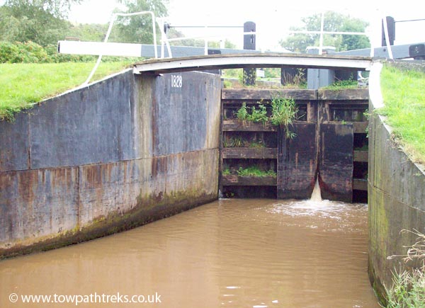
Back at Commercial Road Lock. The lock, like the others, is duel. There are two locks side by side with one having been weir-ed. The weir-ed lock has its gates removed and means that the canal will regulate its level. The weirs mean there is no need for lock keepers to monitor the water levels. Luckily the lock keepers houses remain.

With the dock and the lock behind us we set off for Islington. Salmon Lane Lock is not far from Commercial Road Lock. There is handsome set of lockside houses besides Salmon Lane Lock. Its windows are barred but the loud music coming from inside suggests it’s somebody’s home.

There is little left of the industry that once surrounded this canal. There is a lone chimney with no mill or factory to go with it. On the right is an old warehouse once rented by Doctor Barnardo to be used as a home for his ragged boys. Opposite are blocks of new apartments, some still under construction besides Johnson’s Lock.

At Mile End there are two brick bridges before Mile End Lock. The lock keepers cottage has a very modern extension. It is one of those things that will divide opinion. It means the lock keepers house is well maintained and still in use which has t be a good thing but how will it look in 10 or 20 years? I can’t see it lasting as well as the original building.

The area was once known for its slums but now has Mile End Park instead. The park area reminded me of the Garden Festival Site in Liverpool. It must have looked good when it was opened and new but now, in February 2008, it was looking a bit run down. On the offside of the canal there are large blocks of new apartments or offices. Once again there is no sign of the people who live and work there. The old film of a horse drawn barge taking coal up the canal shows people waving at the camera from their back gardens, or stood on bridges. Where is this community now?

Next I spotted a pair of boundary posts. One has been broken off near its base. The other is leaning forward a bit and has some spray paint on it. It is possible to make out a few letters but I couldn’t tell what it said.

Had the weather been better and my shoes more comfortable we would have walked along the Hertford Union Canal which joins the Regents Canal just before Victoria Park. The canal is only a mile and a quarter long, linking up with the Lee Navigation. It was never successful as a commercial waterway. Note the stop lock at the junction to control the trade and water.

The towpath is popular with runners and cyclists. Not all the bikers have taken on board the Two Tings message so keep your wits about you.

At Old Ford Lock there are some canal buildings that could be stables. A police horse was patrolling Victoria Park and as I ducked under the next bridge I realised the canal horses must have been short as well as strong.

Approaching Bethnal Green the canals surroundings become a bit more urban. There is a large gas holder and an interesting archway on the offside. Coming into town and the shopping centre there are signs that the area has seen some of the regeneration that the rest of the canal has. It’s not long before there are more luxury apartment blocks. Who lives in them?! The brand new buildings make the old brick bridges look out of place. There is a new railway bridge over the canal before Kingsland Basin. The bridges on this section have sign posts telling you not only the names of the bridges but the walking time in between them. This canal has very good signage and a lot is done to promote the use of the towpath.
After Sturts Lock there are two large basins, Wenlock Basin and City Road Basin. While passers-by took photos of a narrow boat going through the next lock I was more impressed by the 1960s Norman moored opposite City Road Basin. At first I thought it was a Norman 25 but it had a sun deck at the back which would make it longer. It was in a bit of a sorry state but it was nice to see a Norman on the Regent’s Canal. Next to the Norman was another information board with a handle to wind. This time it was a lock keeper’s voice telling us about his life on the canal.
Past the lock and through a bridge and we were at the eastern portal of the Islington Tunnel. It’s tempting to try to see down the tunnel but I just held my camera out to see if I could photo the light at the other end.
There is no towpath through the tunnel so horses were taken over the top.
We left the canal and headed up hill into Islington. We stopped off at an antiques market where I bought some postcards of Southport and Liverpool. The postcard of the Pierhead might show the wall that was recently uncovered by the canal link excavations. On top of the tunnel there are shops, bars, restaurants as some very nice houses. There are some blue signposts showing the way to the other side of the tunnel but these signs seem to stop around Sainsbury’s. While we were stood looking at the A-Z wondering where to go next a passing local asked if we were looking for the canal! How did he guess? He complained about the lack of signs and pointed us in the right direction. Through a housing estate and down Muriel Street and there was the canal again, emerging from beneath us. It’s easy to get back onto the towpath at the tunnel. With weary feet and legs we walked to the next bridge and left the canal to walk back to Kings Cross to buy sandwiches which we ate at the British Library.

I enjoyed this walk. I wish I had worn my trainers rather than my Royal Mail boots. The towpath is good throughout and busy with runners and cyclists. The Regents Canal has excellent information boards and the audio feature is a great idea. It is a bit of a shame that there are few historical buildings along the route. Unlike Blackburn or Burnley all trace of the past has been replaced by new buildings. The canal has retained its lock keeper cottages and the one at Mile End Lock has been brought into the 21st Century.
Given the choice I would pick to walk through Regents Park rather than Bethnal Green. Limehouse Basin would be worth visiting as part of a River Thames walk. The Regents Canal is a good example of how canals can bring wealth and regeneration to areas but could also be a warning about soul-less developments.

Monday, February 18, 2008

Canal Walk: Johnson’s Hillock to Withnell Fold ~ 4 miles

A cold and frosty February morning is perfect for a towpath trek. It has been a while since I had a decent walk by the canal so this sunny Sunday it was off to Johnson’s Hillock locks to stretch the legs and refresh the lungs. The area around Johnsons Hillock and Withnell Fold is the George Birtill country. In the 1960s George Birtill wrote lots of books about walking around Lancashire and the history of the towns and lanes around Chorley.
We parked on the road opposite the Top Lock pub; there is a large car park for patrons of the pub and, if you are early, ample parking on the road alongside the canal. The pub hadn’t yet opened when we arrived and there were only a couple of cars parked on the road.
Besides the Top Lock is the lock keepers house, a solid stone 2 storey house. The house is for sale, a perfect place to live if you like canals. And not only is it just a few steps from the pub it has a milepost in the garden!
This stretch of canal is one of my favourite bits of the Leeds & Liverpool. The canal is built on the hillside; on one side there is a steep slope down to the valley bottom on the other side is a high cutting. The 7 Locks at Johnsons Hillock are the work of the great John Rennie. The bridges here look to be the work of Rennie too. They are angled up the hillside. These bridges have a chunkier look than other bridges, their arches are higher, you don’t have to duck as much to walk underneath them. A group of shaggy ponies stood on bridge #84 and watched us pass beneath them.
Between Brown House Bridge #86 and Jacksons Bridge #87 is a tall viaduct linking two fields separated by gorge. It’s certainly picturesque though one wonders why those two fields needed such an expensive structure to link them.
The towpath would have been muddy if it hadn’t been frozen, the frost was melting in the sunshine but there was still enough ice on the canal for the ducks to walk on.
At bridge #88 is Withnell Fold an industrial town. This was once the site of a paper mill and now a nature reserve. The sludge ponds are home to all sorts of wildlife. Even though they were frozen over and it is winter we still spotted lots of tiny fish swimming about. The town of Withnell Fold doesn’t look very inviting from the towpath so rather regrettably we didn’t explore it. Birtll informs us that there is a pretty village square surrounded by workers houses. Maybe next time I will find them.
Near to bridge #88 is a half mile post and a milestone with a bench mark carved on top.
We turned around here and headed back to the locks. We just about spotted milepost 49 covered in ivy behind a fence near to Brown House Bridge.
On the walk back to the lock there were more walkers and a couple of cyclists. Back at the pub there were a lot more cars and the tables outside the pub were taken by drinkers and their dogs. We had lunch in the car and then walked down the locks to lock four. Once again I tried to work out the rope marks on the bridge its hook. We left the canal at Fourth Lock Bridge. The farm building is dated 1727 and has the letters P, H and I. I would guess the date and initials mark a marriage. The date is 43 years before the canal was started. I wonder if the couple saw the canal being built.
Further on down the road is the former Navigation Inn, now a private house. The Navigation was once frequented by bargemen working on the Walton Summit branch which came past here. The branch is now filled in and its hard to see where it ran from the road but you can trace its course on google earth. Over the road from the ex-pub is a car park and the surviving quarter of mile of the Summit Branch, complete with quarter mile post.
We walked up to the junction with the mainline. By now the sun was warm so we had a nice sit down on a bench then walked back up the locks to the car.

Wednesday, January 09, 2008

Canal Walk: Keighley to Saltaire

With the engineering work on the Airedale line completed it was time to return to Saltaire and do the walk we had hoped to do last year. The weather reports for today had changed from “sunny intervals” to “sunny” and back again for the last few days so we were hoping for good weather. As we left Liverpool the sky was blue and the sun shining, perfect for walking on the canal. Along the motorway it started raining but we were still optimistic, sure that it was just a passing cloud.
We parked at Salts Mill, Saltaire. There is plenty of free parking and at weekends you can park right outside the entrance to the mill, close to the station.
We just missed one train but it was only 20minutes till the next one so we popped into the Mill to have a quick look at the book shop (toilets available).
It is about 10minutes from Saltaire to Keighley on the train. Along the way you can see the canal running alongside. You get a good view of Dowley Gap aqueduct (and the sewage farm next to it) and the locks in Bingley.
Keighley station is very nice, a steam railway uses one platform and it has kept a lot of its old fashioned charm.
The canal is about a mile away from the station; it doesn’t go to Keighley itself but follows the contour of the valley side above the River Aire. There was once a plan to build a branch from the main line to Keighley but it was too expensive. After a quick, hot, and not so gourmet sausage roll from the CO-OP near bridge #197 we got onto the towpath at Stockbridge.
Throughout the walk there were plenty of people out walking and cycling. Some people look like they are in a race others look like they are in no hurry at all. We were somewhere in between.
The first couple of miles are about as straight as the canal can be (outside of Burnley). On the left are green fields on the right housing. Just after Morton Swing bridge #198A is a rather nice house right on the edge of the canal. How nice it would be nice to sit in your living room just inches from the water. They are lucky that canals don’t flood like rivers do. Mileposts 109 and 110 were there but other than them there were few others.
After a nice but not overly interesting stretch we arrived at the famous Bingley Five Rise Locks. Just before the locks is an old stable building now a café. We went in as it says it is a store but they didn’t even have any postcard of the locks outside.
Bingley Five Rise is one of Aikmans Seven Wonders of the canal world, lifting the canal 60ft. The idea is that the top gates of one chamber are the bottom gates of the next. Interestingly they are earlier than flights of single locks elsewhere on the system. At Greenberfield the rise lock was replaced by individual locks in an effort to save water. The locks are very interesting, although like most Wonders a little smaller than I had expected. There are a couple of features worth noting. The ground paddle gear is housed in boxes with the handle on top. The gate paddles on some gates are rather interesting. They are scissor cloughs, which are wound with a handle and use a horizontal rack to open the clough or paddle. This is the first time I have seen a scissor clough though they are said to be on the locks at Blackburn and Stanley Dock. Also note the overflow channel from the lock chamber to the by-pass channel.
After the Five Rise there are some new apartment buildings built to look like converted warehouses or mills. Then come the little brother of the Five Rise the Bingley Three Rise. There are brand new gates on the Three Rise, they haven’t been painted and have no winding gear attached yet. The by-pass channel of the three rise goes underneath the lock side buildings.

Next to the three rise is the Damart factory. It’s a large stylish building, a complete contrast to the modern sheds built today. The canal towpath was moved here to accommodate the road next to it. I was pleased to see that the half mile post had been relocated and is now bolted to the wall.

The towpath is good for the whole of this walk and is a cycle route so watch out for cyclists without bells. The canal is clean here but there was a fridge floating in the cut, is it the same one I saw in Blackburn last year..?

Near Maud bridge #204 the canal is overlooked by tower blocks, they must have great views but don’t do much for the scenery themselves. Before the next bridge there is a bus stop on the towpath, but this is for a water bus so don’t worry about being run over by the number 78. After Scourer bridge #205, is Dowley Gap 2 Rise Locks and Changeline Bridge #205. This is a very nicely kept stretch and has the plaques to prove it; it is award winning. After the locks is the Dowley Gap Aqueduct which carries the canal over the River Aire. You can turn off the towpath here and get a view of the arched aqueduct. There is a path here which seemed to be popular with walkers and cyclists, it follows the river but I don’t know how far or where it goes. Back on the towpath we were bothered by midges, there is no sign of a date on the stonework but I am sure there must be one somewhere.

At Hurst Lock (a single lock) we saw the first moving boat of the day. It was heading towards Bingley and had plenty of photos taken of it. Soon Saltaire was in sight, the mill chimneys and the church tower rising over the trees. The church in Saltaire is very well designed; I think it’s my favourite building in the town.

Back in Saltaire the walk was over. We went for a sandwich at the tea room on Victoria Road and gave our feet a rest. It would be good to have a guide book to the buildings of Saltaire but I have yet to find one.

This is obviously a popular stretch of canal for walkers and cyclists. It includes the Bingley Five and Three Rises and the Dowley Gap locks and aqueduct. I would imagine that the tree-lined bits are very nice when they are in full leaf. For me it lacks some industrial archaeological curiosities, something to figure out and wonder about. For quite a while the canal is close to the A650 and you can hear the traffic. I would recommend the shorter walk from Bingley to Saltaire.

Now I have walked the first 115 miles from Liverpool Pall Mall to Oddies Swing bridge; that leaves just 12.25 miles to go. Whether we will do it as one walk or two remains to be decided but the plan is to stay in Leeds.